Add a Curriculum Bundle to Your Account!
Please select a bundle.




The Pack contains associated resources for the learning experience, typically in the form of articles and videos. There is a teacher Pack (with only teacher information) and a student Pack (which contains only student information). As a teacher, you can toggle between both to see everything.
Here are the teacher pack items for Southern Coastal South America: Geographic Passport:


Overview In this experience, students examine the physical geography of Chile, Argentina, and Peru by identifying major landforms, climate patterns, natural resources, and population patterns. They take a closer look at the Andes Mountains, the Pampas, and Patagonia to compare how different environments influence where people live and how they use the land. Finally, students choose a place in the region and create a short travel entry explaining how its geography shapes what they might see or experience there. Divide the students into three large groups for scenes 2 and 3, and assign each group one of the countries: Chile, Argentina, or Peru. Students can do the research individually, in pairs, or in small groups, but each student should post individual responses. Objectives:
Southern Coastal South America includes Chile, Argentina, and Peru, three countries with very different landscapes. The region includes the Andes Mountains, the Atacama Desert, fertile valleys, grasslands, long Pacific and Atlantic coastlines, and some of the highest elevations in the Americas.
These physical features influence climate, settlement, natural resources, transportation, and the ways people use the land.
In this experience, you will explore the physical and human geography of Chile, Argentina, and Peru and examine the geographic features that make each country distinct.
Objectives:
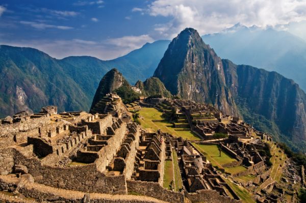
The mountain Huayna Picchu overlooks the Inca estate of Machu Picchu
Southern Coastal South America is home to the Andes Mountains, one of the longest mountain ranges in the world. People have lived in the Andes for thousands of years and have developed ways to farm, travel, build communities, and use resources in steep, high-elevation environments.
The image of Machu Picchu in Peru shows one example of how the Inca built a community in the Andes more than 500 years ago. Its location reflects both the opportunities and challenges that mountain geography can create.
Think about how living in a mountainous environment might affect daily life.
Use the image and what you know about mountains to make predictions. In the first column, describe ways mountain geography could affect daily life. In the second column, explain how people might adapt to those conditions.

Student responses will vary. Look for reasonable connections between mountain geography and daily life, such as steep slopes affecting travel and farming, high elevations influencing temperature and weather, or limited flat land affecting where communities are built. Students may suggest adaptations such as terrace farming, roads or paths designed for steep terrain, building on flatter areas, using irrigation, or choosing crops and animals suited to higher elevations. Emphasize that people in the Andes have adapted to mountain environments for thousands of years. The goal is not for students to guess one correct answer, but to recognize that geography can create both challenges and opportunities and that people develop different ways to live within those conditions.
In the next scene students will work in their small groups. When everyone is ready to continue, unlock the next scene.


