Add a Curriculum Bundle to Your Account!
Please select a bundle.


The Pack contains associated resources for the learning experience, typically in the form of articles and videos. There is a teacher Pack (with only teacher information) and a student Pack (which contains only student information). As a teacher, you can toggle between both to see everything.
Here are the teacher pack items for West and Central Africa: Geographic Passport:

Overview In this experience, students examine the physical geography of West and Central Africa by comparing maps of location, climate, elevation, natural hazards, and population. They then investigate one country to explain how geography influences where and how people live. Finally, students explore an environmental challenge to analyze how physical conditions and human choices can create both opportunities and challenges for communities. Objectives:
People living in the same broad region do not necessarily experience the same geographic conditions. Differences in climate, elevation, access to water, natural hazards, and other physical features can shape where people live, how they move, what economic activities are possible, and how communities adapt to their surroundings.
West and Central Africa stretches across a large part of the African continent. It includes coastal countries along the Atlantic Ocean as well as countries located farther inland. Across the region, physical environments range from dry areas in the north to tropical forests closer to the equator.
In this experience, you will use maps and country research to examine geographic patterns across West and Central Africa and investigate how physical geography creates both opportunities and challenges for people.
Objectives:
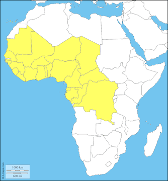
Use the map to examine the location of countries in West and Central Africa. What is one important difference you notice in the locations of countries within the region? Use evidence from the map.
After students respond, invite several students to identify the geographic evidence they used. Use the discussion to establish that West and Central Africa is a large region containing countries in different geographic positions. Some have Atlantic coastlines, while others are landlocked. Countries also differ in size, latitude, and location within the region. Do not ask students to predict detailed climate, population, or environmental conditions yet. They will examine those patterns using additional maps in the next scene. Possible follow-up questions include:
When everyone is ready to continue, unlock the next scene.


